Rail transit
InfiPoints
Shutoko engineering co., LTD. (hereinafter referred to as "Shutoko engineering"), Aero Asahi Corporation and Elysium have teamed up to simplify the maintenance and reconstruction of highways and structures using geographic information and three-dimensional scanning point cloud data.
Shutoko project has accumulated the professional knowledge of highway and building maintenance and scanning data, big scanning data management system, also need to reasonably support the work of engineers, including maintenance, renovation design, construction plan and project consulting, by using the attributes of scanning data to simplify the work required.So they formed a consortium, developed by Elysium and Aero Asashi, an industry expert in 3D data conversion and geometric processing technology, to quickly apply the scanning data to the actual operation of municipal facilities transformation and maintenance.
Infrastructure maintenance
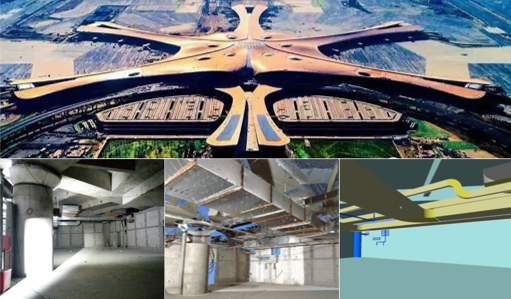
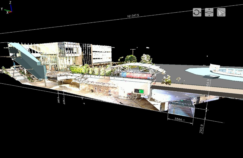
InfiPoints help the structure of the highway and maintenance work, will come from various 3 d laser scanning data (such as static scanners, MMD scanning system), a quick look at the current state of the infrastructure, distance and Angle measurement of the highway, all kinds of construction of virtual maintenance simulation, and can be generated from point cloud data of 2 d drawings.
Three-dimensional construction simulation
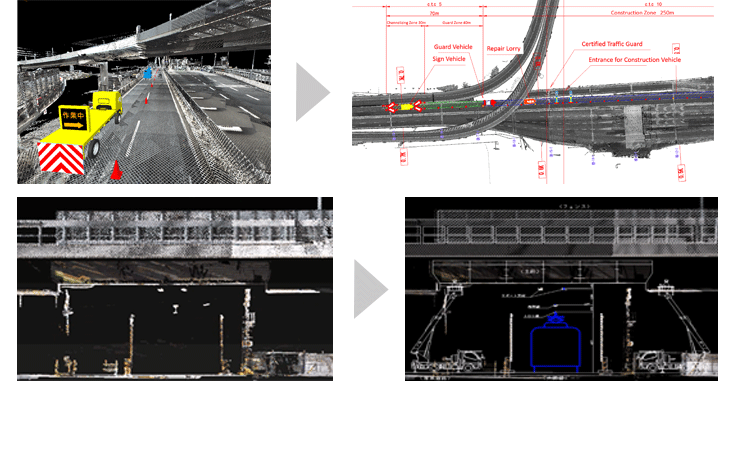
Usually borrow from 2 d drawings and photographs to plan the structure of the bridge maintenance vehicles or aerial work platform, check your homework InfiPoints for construction vehicle and bridge structure in virtual environment, the collision detection between the user can advance the feasibility of the simulation heavy equipment operation, and Shared between cooperative unit in advance to check operation methods and procedures.This prevents rework situations, such as those where the construction vehicle is found to be unsuitable or unable to perform the operation at the site.
Two-dimensional drawing
It usually takes a lot of time to create CAD data for highways, because CAD drawings need to be completed based on two-dimensional drawings and measurement results, and even old CAD drawings of highways and structures cannot be completed.
Driving safety simulation
Highway construction maintenance, must draw CAD drawings, according to road closed or vehicle scheduling, through the visualization of 3 d scanning data, editing, data processing technology, InfiPoints allowed from the scanning data and geographic information quickly create drawing, on the other hand, can be implemented in the scan data of virtual environment to simulate the construction area, vehicle and to confirm the details in advance.
Shutoko engineering co., LTD. (hereinafter referred to as "Shutoko engineering"), Aero Asahi Corporation and Elysium have teamed up to simplify the maintenance and reconstruction of highways and structures using geographic information and three-dimensional scanning point cloud data.
Shutoko project has accumulated the professional knowledge of highway and building maintenance and scanning data, big scanning data management system, also need to reasonably support the work of engineers, including maintenance, renovation design, construction plan and project consulting, by using the attributes of scanning data to simplify the work required.So they formed a consortium, developed by Elysium and Aero Asashi, an industry expert in 3D data conversion and geometric processing technology, to quickly apply the scanning data to the actual operation of municipal facilities transformation and maintenance.
Infrastructure maintenance
InfiPoints help the structure of the highway and maintenance work, will come from various 3 d laser scanning data (such as static scanners, MMD scanning system), a quick look at the current state of the infrastructure, distance and Angle measurement of the highway, all kinds of construction of virtual maintenance simulation, and can be generated from point cloud data of 2 d drawings.
Three-dimensional construction simulation
Usually borrow from 2 d drawings and photographs to plan the structure of the bridge maintenance vehicles or aerial work platform, check your homework InfiPoints for construction vehicle and bridge structure in virtual environment, the collision detection between the user can advance the feasibility of the simulation heavy equipment operation, and Shared between cooperative unit in advance to check operation methods and procedures.This prevents rework situations, such as those where the construction vehicle is found to be unsuitable or unable to perform the operation at the site.
Two-dimensional drawing
It usually takes a lot of time to create CAD data for highways, because CAD drawings need to be completed based on two-dimensional drawings and measurement results, and even old CAD drawings of highways and structures cannot be completed.
Driving safety simulation
Highway construction maintenance, must draw CAD drawings, according to road closed or vehicle scheduling, through the visualization of 3 d scanning data, editing, data processing technology, InfiPoints allowed from the scanning data and geographic information quickly create drawing, on the other hand, can be implemented in the scan data of virtual environment to simulate the construction area, vehicle and to confirm the details in advance.